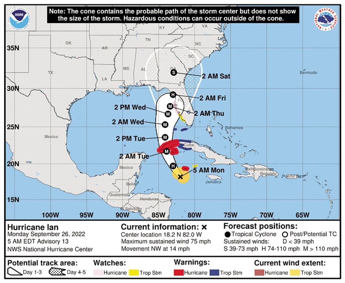
Hurricane Ian is predicted to drop between six and eight inches in Southeast Georgia as it moves north after making landfall somewhere along the Florida gulf coast.
That’s the area forecast of those tracking the first major storm to impact the continent this hurricane season.
“It’s probably going to be mostly a rain event for us,” Ware County Emergency Management Agency Director Jonathan Daniell said Monday afternoon following a conference call with the National Weather Service in Jacksonville. “It’s looking like six to eight inches over the course of two to three days with maybe more in localized areas. That’s going to bring problems to the dirt roads and some low areas.”
The storm, which developed into a hurricane on Monday, is expected to make landfall sometime tonight (Wednesday, September 28).
Rains from the storm’s outer bands are expected to reach the area late tonight or early Thursday morning and continue into the early morning hours of Saturday before becoming sporadic.
“It looks like Thursday is going to pretty much be a bad day, all day,” Daniell said. “The storm has slowed at little so now it looks like Thursday and Friday (will be worst).”
The NWS has placed the area in a moderate flooding zone because of the amount rain expected. Daniell said most low-lying areas that flood during heavy thunderstorms that drop multiple inches of rain will be the major concern.
Flooding from the Satilla River shouldn’t be a problem, he said. With no measureable precipitation in the area for nearly two weeks, the river is well below flood stage.
“I don’t think we have a worry (with the Satilla),” Daniell said. “The dirt roads will be the main thing. Hopefully, they won’t be impassable, but minimzing travel (during storm) will help a lot.”
The director said unless the storm tracks farther north than current models show, winds shouldn’t be damaging, but still strong enough to blow around unsecured items and cause power outages.
“People need to be conscious about outside items,” Daniell said. “Everything needs to be secured to minimize the flying debris.”
He also reminded that pets should be kept inside, and if that isn’t possible, they should have suitable shelter and food/water to weather the storm.
Daniell also said if there is a power outage, and a fuel-powered generator is used to maintain electricity, that it’s operated outside.
Forecasters expect the rain to begin falling in Southeast Georgia late tonight with periods continuing through the early morning hours of Saturday, October 1, depending on the storm’s track.
There’s a 60 percent chance of rain tonight with northeast winds around 15 mph and temperatures in the low 60s.
Conditions likely will begin worsening Thursday with overnight showers becoming a steady rain as the day progresses. Chance of rain is 80 percent with winds strengthening to 25 mph and temperatures in the upper 60s.
Thursday night, rain continues at a 100 percent clip with winds continuing in the 20 mph range with little change in temperature. Rainfall is expected to be about an inch.
The steady rain is likely to continue most of the day on Friday with another inch or more likely. Winds are predicted to lessen as the day goes on with temperatures in the low 70s.
Rain is expected to become more intermittent into the evening and on into the early morning hours of Saturday with another half-inch expected.
Clearing should come around midday on Saturday with a 50 percent chance of lingering showers and temperatures in the upper 70s.
Because of uncertainty with the storm, Daniell said it was advised to monitor the weather channel and local news outlets for the latest information. Localized information is available online by checking https://www.weather.gov/jax/


